"Hi everyone!, I'm starting to work on a project where I need to use a smartphone's GPS to track speeds, distances and moving or changing locations, therefore I need a native mobile app. Do you know the best no code tool for this kind of project? one that can use a phone's GPS, not that hard to learn and that could possibly not break the bank..."
This plea for help, posted on r/nocode, captures a frustration shared by thousands of developers, entrepreneurs, and small business owners. The user needed something seemingly simple: a mobile app that tracks GPS data. Speed. Distance. Location changes. Basic stuff that every smartphone can already do. Yet the path to building this app felt impossibly complex or prohibitively expensive.
The post struck a chord because it exposes the gap between what technology can do and what individual developers can actually access. GPS tracking isn't rocket science—your phone does it constantly for Google Maps, Uber, fitness apps, and countless others. But try building your own GPS tracking app, and suddenly you're looking at native development in Swift or Kotlin, backend infrastructure for data storage, real-time processing challenges, and budgets that make small projects financially impossible.
The irony isn't lost on anyone in the development community. GPS functionality is built into every smartphone. The hardware exists. The operating system APIs are documented. Yet turning this ubiquitous capability into a custom application traditionally requires either significant technical expertise or substantial financial resources.
Traditional Development Path:
This path makes sense for venture-backed startups building the next Uber. It makes zero sense for a developer who needs GPS tracking for a specific business use case, a personal project, or a client with a limited budget.
The Reddit user asking this question represents a much larger group: people who need functional mobile apps without the overhead of traditional development. They're not building consumer apps competing for millions of downloads. They're solving real operational problems—tracking delivery vehicles, monitoring field teams, logging athlete training data, or recording inspection routes.
Let's be clear about what most GPS tracking projects require. The Reddit user mentioned tracking "speeds, distances and moving or changing locations." Break that down into specific capabilities:
Notice what's NOT on this list: complex algorithms, machine learning, social features, payment processing, or any of the complications that justify hiring development teams. The core GPS tracking functionality is straightforward. The challenge has always been accessing it without writing thousands of lines of code.
The difficulty isn't in the GPS itself—it's in all the surrounding requirements. Native mobile apps need:
Platform-Specific Code:
Backend Infrastructure:
Battery and Performance:
Permission and Privacy:
For a development shop with resources, these challenges are manageable. For an individual developer or small business, they become barriers that either kill projects or force compromises that undermine functionality.
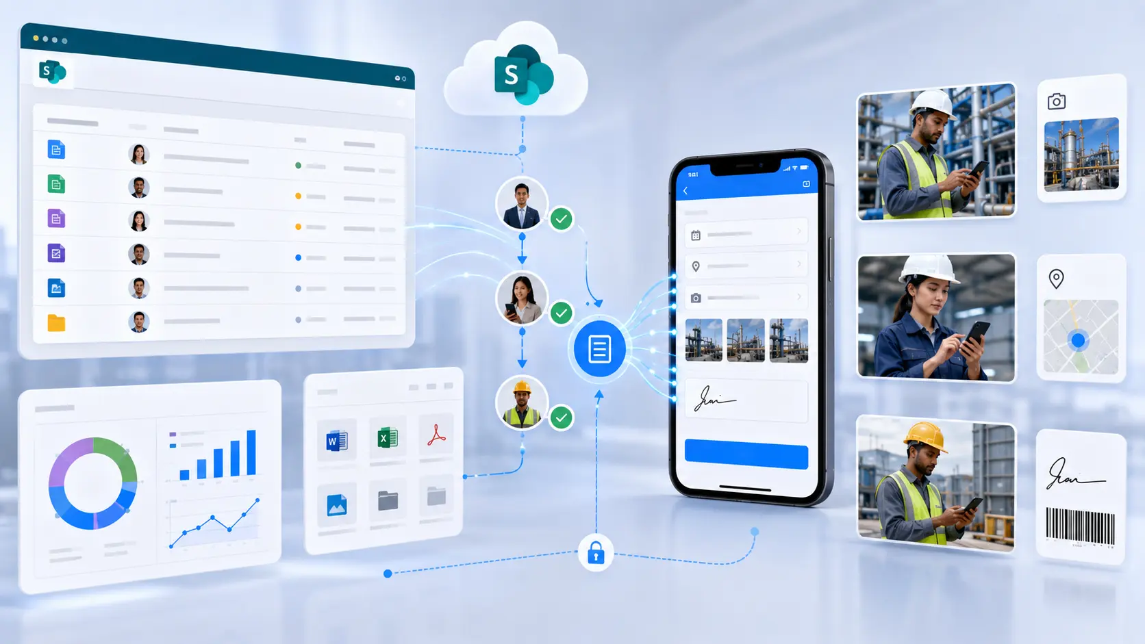
The emergence of comprehensive no-code platforms fundamentally shifts what's possible. Instead of building GPS tracking from scratch, developers can now assemble apps using pre-built components that handle all the complex infrastructure automatically.
Here's what changes with no-code GPS tracking:
Immediate Mobile Access:
Built-in Data Management:
Pre-Optimized Performance:
Compliance Handled:
The Reddit user asking about no-code GPS tracking tools was onto something. The question isn't "Can no-code handle GPS tracking?" but rather "Why would anyone still build GPS tracking the traditional way?"
GPS tracking isn't just about dots on a map. Different use cases need different approaches, but all benefit from accessible development:
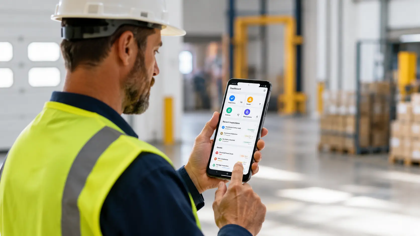
Companies with mobile workforces need to know where teams are, how long jobs take, and whether service areas are being covered efficiently. Field sales tracking combines GPS location capture with visit logging, allowing managers to see not just where reps went, but which clients they visited and how long each meeting lasted.
Live tracking provides real-time visibility—dispatchers can see all field workers on a single map, making it easy to assign nearby team members to urgent requests or verify that scheduled appointments are being kept.
Every delivery business faces the same question: "Where's my package?" GPS tracking answers this for both business and customer.
Delivery drivers use mobile apps that automatically log each stop with GPS coordinates, creating proof of visit. Delivery confirmation workflows tie location data to customer signatures and photo proof, building complete delivery documentation.
Route efficiency improves when businesses can analyze actual paths taken versus planned routes. Distance calculations show which routes burn unnecessary fuel, while speed tracking identifies areas where drivers consistently slow down, indicating traffic problems or routing issues.
Paper timesheets and honor-system attendance don't work for distributed teams. GPS-verified check-ins solve this.
Employee attendance systems with GPS location capture let workers clock in from their smartphones, automatically recording where they were when they started and ended shifts. This isn't about distrusting employees—it's about having accurate records for payroll, compliance, and dispute resolution.
Geofencing adds another layer: employees can only clock in when physically present at job sites. The system automatically validates location against predetermined boundaries, preventing buddy punching and ensuring workers are where they need to be.
Athletes and fitness enthusiasts want the same GPS capabilities that professional training apps provide. Track runs, bike rides, hikes—record distance, speed, elevation changes, and route paths.
Custom fitness apps can be tailored to specific sports or training programs. A rowing coach might want to track water routes differently than a cycling coach tracks road routes. With accessible GPS tools, creating sport-specific trackers becomes feasible for individuals and small organizations.
Inspectors traveling to multiple sites need to prove they actually visited each location. GPS timestamps provide this verification automatically.
Inspection reports with embedded GPS data create audit trails showing exactly when and where each inspection occurred. Equipment checks, safety audits, property assessments—any inspection workflow benefits from location verification.
The location data also helps optimize inspection routes. By analyzing travel patterns, organizations can schedule inspections more efficiently, reducing drive time and increasing daily productivity.
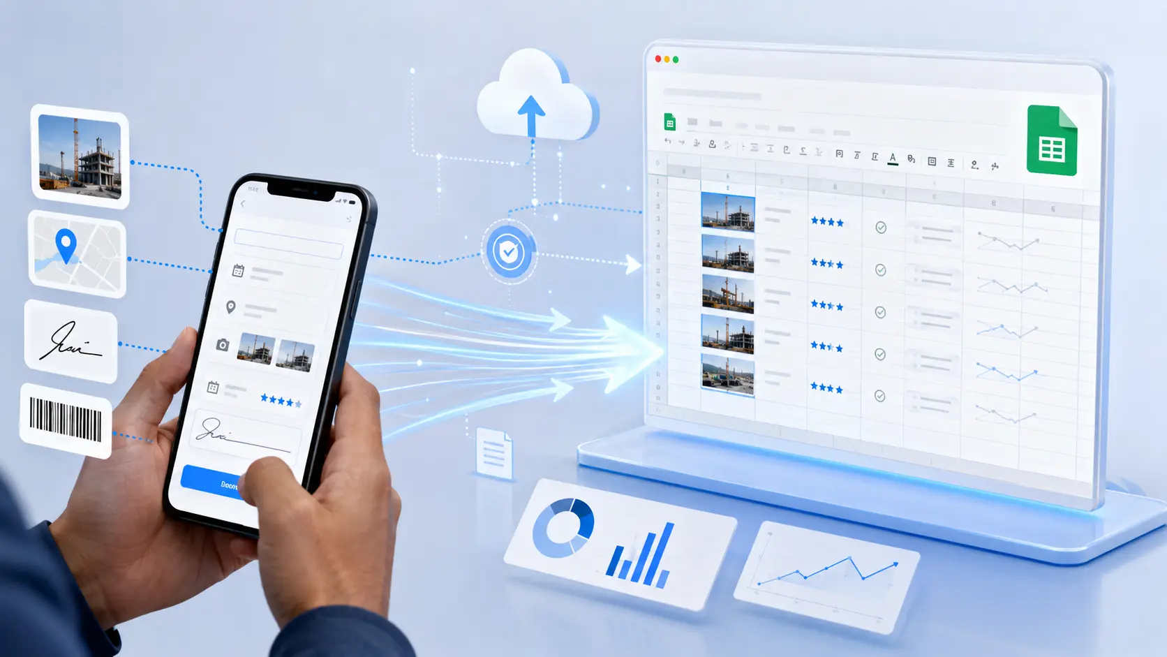
Let's walk through what actually happens when you build a GPS tracking app without code. Understanding the process demystifies what once seemed impossibly complex.
The Complete GPS Tracking Flow:
This workflow represents what users experience. Behind the scenes, the no-code platform handles all the technical complexity—API calls, database operations, real-time syncing, and map rendering—without requiring any of it to be manually coded.
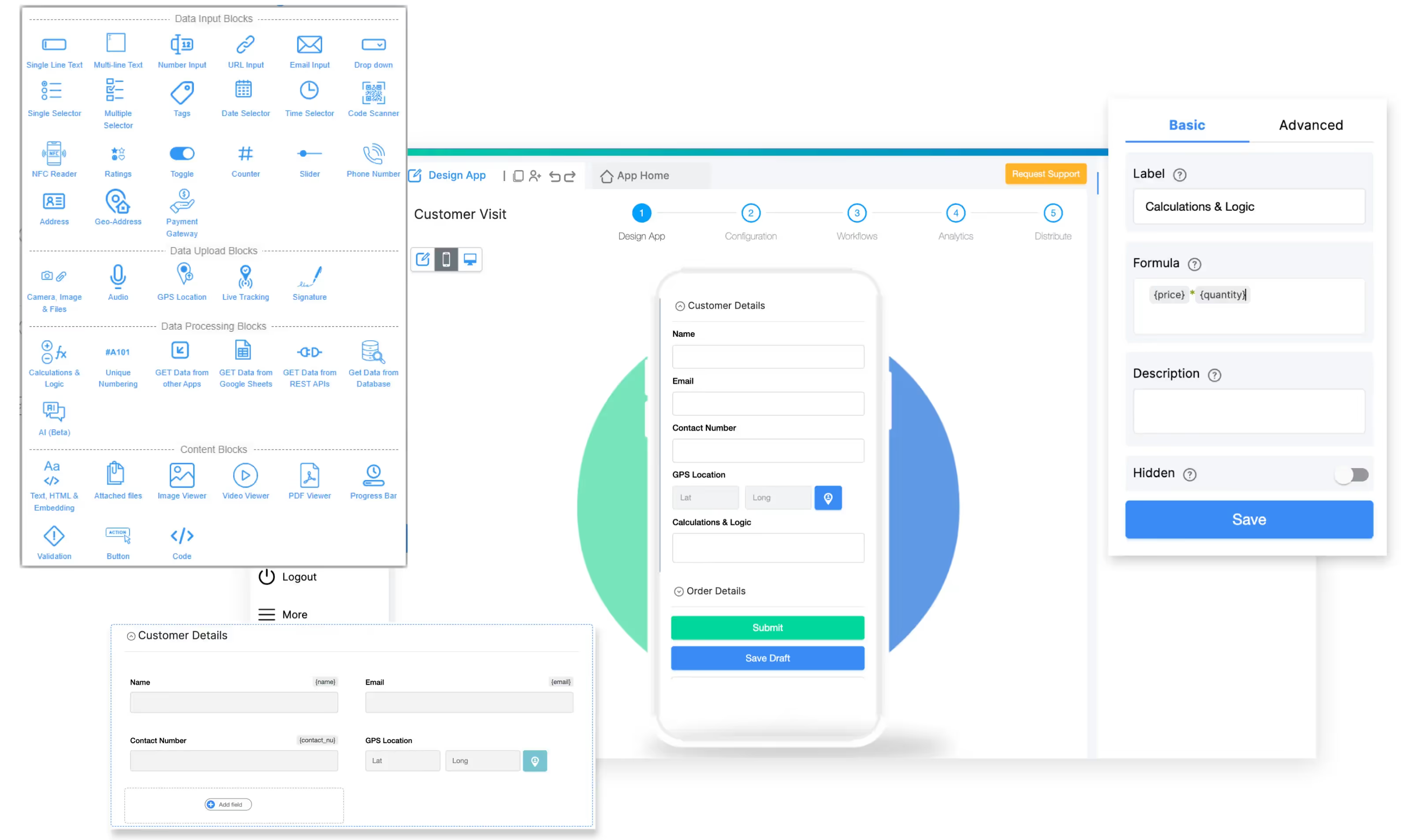
The actual build process is simpler than most developers expect. With platforms like Clappia, you're configuring rather than coding.
Start with the Form:
Create a new mobile app. Add basic fields to capture context around tracking sessions:
Add GPS Components:
Drag the GPS Location block onto your form. Configure it to capture:
Enable Live Tracking to continuously update location while the app is open. Set update frequency based on your needs—more frequent updates provide better route detail but use more battery.
Configure Calculations:
Add formula fields to automatically calculate:
These calculations happen automatically without writing a single line of code. The platform handles the mathematics, you just specify what you want calculated.
Set Up Data Storage:
Every GPS point captured is automatically saved to your database. Configure what information each record should store:
The database is created automatically, scaled automatically, and backed up automatically. No server configuration required.
Add Visualization:
Map components display tracked routes. Configure map layers to show:
Users can interact with maps—zoom, pan, click markers for details—all working out of the box.
Build Team Access:
Set permissions so different users see appropriate data. Field workers might see only their own tracking history. Managers might see all team members. Clients might see only deliveries relevant to them.
Access controls are configured through interfaces, not coded. Assign roles, define what each role can view and edit, and the system enforces these rules across all devices.
Raw GPS data is useful, but automated workflows turn tracking information into actionable insights.
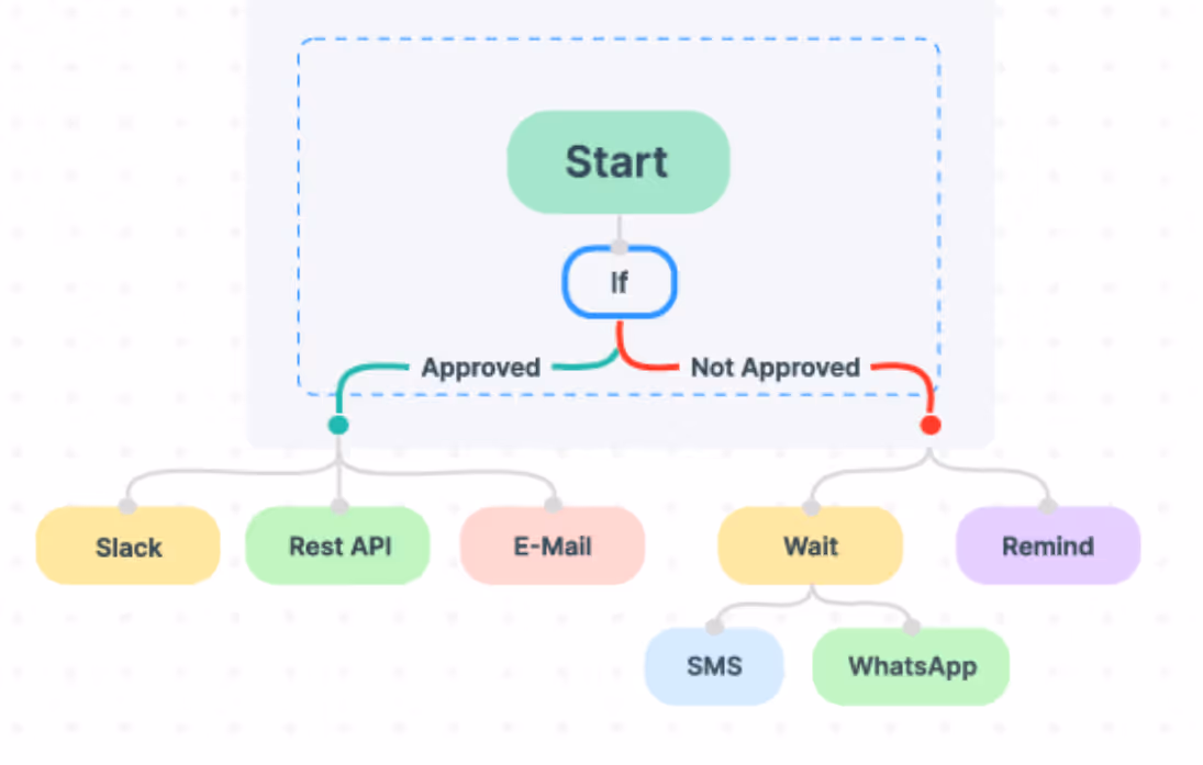
Geofence Triggers:
Define geographic boundaries around job sites, warehouses, customer locations. Automated workflows trigger when users enter or exit these zones:
These triggers replace manual logging. Workers don't need to remember to clock in—arrival does it automatically.
Speed and Distance Alerts:
Set thresholds that trigger notifications:
Automated Reporting:
At the end of each day, week, or month, automated reports compile tracking data:
Reports can be emailed to managers, saved to company drives, or fed into other business systems through integrations.
Predictive Insights:
Analyze historical tracking data to predict future needs:
These insights emerge from accumulated data without requiring statistical expertise or data science teams.
Here's what the Reddit user meant by "not break the bank"—traditional GPS tracking app development has hidden costs that add up fast.
Traditional Development Costs:
Consumer GPS Tracking Apps:
No-Code GPS Tracking:
The cost difference isn't marginal—it's order-of-magnitude different. Projects that would require substantial budgets with traditional development become accessible to small businesses and individuals.
The Reddit post mentioned needing GPS tracking for a specific project. This is key: most GPS tracking needs are project-specific, not generic.
Generic GPS tracking apps are built for mass markets. They offer:
But actual business needs are specific:
Generic apps force businesses to adapt their workflows to the software. Custom development lets businesses get exactly what they need but at prohibitive cost.
No-code platforms offer a third option: build exactly what you need, with the speed and cost benefits of pre-built components. The GPS functionality is standardized and optimized. The workflow around it is completely customizable.
This is why platforms like Clappia see GPS tracking used in wildly different ways: employee monitoring, asset tracking, delivery logging, inspection verification—each implementation tailored to specific operational needs while using the same underlying GPS capabilities.
Responses to the original post pointed the user toward no-code options. This represents a shift in how developers think about tools.
A decade ago, "real" developers built everything from scratch. Using pre-built tools was seen as taking shortcuts. Today, smart developers recognize that reinventing wheels is wasteful. GPS tracking is solved technology. The value isn't in implementing GPS—it's in applying GPS data to solve specific business problems.
The developer asking about no-code GPS tools wasn't admitting defeat—they were being pragmatic. Why spend weeks learning native mobile development to build something that already exists in component form?
This pragmatism extends beyond individual developers. Companies are recognizing that custom development resources should focus on actual competitive advantages, not rebuilding commodity functionality. If GPS tracking, form building, data storage, and user management can be assembled from reliable components, development teams can focus on the unique aspects of business logic that actually differentiate the product.
For anyone reading that Reddit post and thinking "I need this too," here's the path forward.
Define Your Specific Use Case:
Don't just say "GPS tracking." Get specific:
Specificity guides configuration choices.
Build a Minimum Viable Tracker:
Start simple. Your first version should:
Get this working, then expand. Don't try to build every feature immediately.
Test in Real Conditions:
GPS tracking behaves differently in different environments:
Test your tracker in the actual conditions where it will be used. Adjust update frequency, accuracy requirements, and battery optimization based on real-world performance.
Iterate Based on Usage:
Once users start tracking, you'll discover what matters:
The beauty of no-code development is that these iterations don't require development cycles. Adjust, test, deploy—all without writing code.
GPS data isn't just about knowing where things are—it's business intelligence about how operations actually function.
Efficiency Analysis:
Compare planned versus actual routes. Are drivers taking shortcuts that save time? Or detours that waste fuel? GPS tracking reveals the difference between theoretical efficiency and operational reality.
Time studies become automatic. How long do service calls actually take? How much time is spent driving versus working? These insights emerge from GPS data without stopwatches or manual timing.
Resource Optimization:
GPS tracking shows whether field resources are distributed effectively. Are service territories balanced by actual travel time? Do sales regions make geographic sense? Should you open a new location to reduce travel distances?
These strategic decisions benefit from location data that manual tracking can't capture at sufficient scale.
Compliance and Verification:
Many industries require proof of physical presence. Safety inspections must happen on-site. Deliveries must reach destinations. Service appointments must be kept.
GPS tracking with timestamps provides objective verification. This protects both businesses and customers when disputes arise about whether work was actually performed.
Customer Service:
Real-time GPS tracking enables proactive customer communication. Instead of customers calling to ask "Where's my delivery?" businesses can send updates: "Your driver is 15 minutes away."
This transparency improves satisfaction even when delays occur. Customers tolerate waiting better when they have visibility into progress.
The Reddit user who asked about affordable, learnable no-code GPS tracking tools was asking the right question. GPS tracking is essential for modern operations, but building tracking apps shouldn't require massive investments or specialized expertise.
Start building your GPS tracking app today—no native development knowledge required, no complex infrastructure to manage, and no budget-breaking costs.
The future of mobile app development isn't about everyone learning Swift and Kotlin. It's about empowering people who understand business problems to build solutions directly, using reliable components that handle technical complexity automatically.
GPS tracking exemplifies this shift. The technology is mature and accessible. The barriers that once made custom GPS apps impractical for most use cases have fallen. What remains is opportunity—for developers, entrepreneurs, and businesses to build exactly the tracking solutions their specific operations need.
The developer asking on Reddit has probably already built their GPS tracker by now. The better question is: what's stopping you from building yours?
L374, 1st Floor, 5th Main Rd, Sector 6, HSR Layout, Bengaluru, Karnataka 560102, India
3500 S DuPont Hwy, Dover,
Kent 19901, Delaware, USA


3500 S DuPont Hwy, Dover,
Kent 19901, Delaware, USA
L374, 1st Floor, 5th Main Rd, Sector 6, HSR Layout, Bengaluru, Karnataka 560102, India
.svg)


.jpg)